OLPC world map
Jump to navigation
Jump to search
For reference, see also this general non-OLPC political map w/ country labels.
2010 maps
-
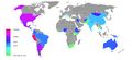 Countries with 500+ kids and teachers w/ XOs, June 2010
 -
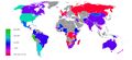 Countries w/ 100+ kids and teachers w/ XOs, Feb 2010


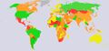
2007 maps
Information about interest in 2007.
-
 Large 3472x1626 GIF
(~1,380 KiB) -
 Medium 1200x562 JPG
(~56 KiB) -
 Small 440x206 GIF
(~31 KiB)


Enumeration by status
See Deployments for status on OLPC country deployments. See OLPC status by country in 2007 for historical country status